Detailed Travel-Report
Browse through RAD + REISEN - EUROCYCLE travel reviews! Find out, how other clients experienced their cycle holidays.
On the specific tour-page you can find a summary of all reviews under the tab "Travel-Reviews".
The effort well rewarded!
Overall:
This tour is more strenuous than most others I’ve done, but I think the extra effort required is rewarded by the alpine countryside and the locations visited.
Highlights
- Garmisch-Partenkirchen
- Bad Tölz
- Wallgau
- Alpine scenery
Niggles:
- The Route/Map Book could be improved; a bit of punctuation would go a long way!
- A rather pokey little room in one hotel.
Regrets:
- After I returned home, I discovered the village of Berg, on Lake Starnberg (visited on day 2), is where King Ludwig II of Bavaria met his mysterious end. In the vicinity of Berg, the cycle path turns some distance away from the lakeside (I recall a distinct climb here), so I didn’t see the monument, in the lake. I would have liked to have seen it. Schloss Berg, where Ludwig was taken after he had been declared “mad”, is also here.
- A slight regret, perhaps, in that I did not cycle all the way to Kastenalm on day 4, Garmisch-Partenkirchen to Wallgau/Krün.
Date of my Tour: 2018-06-16/23 (7 nights / 8 days)
Rad & Reisen’s local agent: Austria Radreisen
Options Chosen:
- 8-day tour
The 9-day tour differs from the 8-day tour I did by splitting day 2 — the München - Starnberg - Murnau (or Seehausen am Staffelsee) day — into two separate days, taking a longer route between München and Starnberg (although the shorter route could be taken if desired — the Route/Map Book contains instructions for all variants) and stopping overnight at Starnberg, continuing on to Murnau (or Seehausen am Staffelsee) the following day. I found this day’s ride the most arduous of the tour, so splitting it into two, or using the other option of sailing across Lake Starnberg, are both means of easing it.
The 7-day tour is the same as the 8-day tour up until Bad Tölz, but, then, whereas the 8- and 9-day tours go from Bad Tölz to Bad Wiessee (on Lake Tegernsee), the 7-day tour heads straight back to München. The Bad Tölz to Bad Wiessee leg is the shortest of the entire tour, but also involves some of the steepest inclines; it felt a bit like a rest-day (or a half-day ride; there is a suggestion to cycle round Lake Tegernsee, 25 km, if you want to extend it), so, if a shorter tour is needed, it makes sense that this this is the section to be omitted.
- Single Room.
- Travel documents in English.
- Bike without a coaster (“back-pedal”) brake.
Materials Supplied
A few weeks prior to the tour, I received a substantial pack of documents from Rad & Reisen:
- A thick, ring-bound Route/Map Book, in German (by mistake).
- Hotel lists, including instructions on how to reach the hotels from the daily cycling route.
- A pamphlet containing recommended restaurants at each overnight stopping point.
- Boat timetables for Lakes Starnberg and Tegernsee (optional boat rides).
- Train timetables for Garmisch-Partenkirchen to Scharnitz (part of the tour) and for Gmund (on Lake Tegernsee) to München (optional, to reduce/avoid cycling on the last cycling day).
- Luggage tags, used to facilitate the daily transfer of luggage between hotels.
- Town Plan of München.
- Receipts.
On arrival at the first hotel (Holiday Inn Süd, München), I was handed a complete documentation package in English, as the German package had been sent to me by mistake.
Additionally, I requested the GPS tracks, which were e-mailed to me. This turned out to be a single, large track covering the entire circular path. I used online GPS mapping software to chop this up into daily sections, customising these for the particular hotels at which I would be staying. The one exception to this one GPS track per day scheme was for day 4, from Garmisch-Partenkirchen to Krün/Wallgau, because this involved riding out along the Isar river valley from Scharnitz to its source and then riding back in the opposite direction, which is guaranteed to confuse a GPS device. So, for this day, I composed two tracks, one from Scharnitz out to the source of the Isar and a second track from the source back into Scharnitz and then onwards to the end of the day’s ride at my hotel in Krün.
Transfers:
I flew to Munich Airport (code MUC). At the airport, I bought a ticket for the municipal transport, taking the S-Bahn (suburban rail network) to Marienplatz (line S-8 is best, though S-1 also goes there, by a longer route), where I transferred to U-Bahn (underground rail network) line U-3 to Machtlfinger Strasse. From here, it’s a short walk to the Holiday Inn Süd hotel. (On Google maps, it looks like you will be walking in a large “U”-shape, but the first limb of the “U” is actually underground; when you emerge from the U-Bahn station — it has a lift and an up-escalator — you just have an “L” left to walk; left from the station and then left at the end of the road.)
At the end of the tour, I needed to get to Munich’s main railway station (“München Hauptbahnhof”) — I had booked the Bavaria by Bike and Boat tour (code 323), departing from Regensburg, and was scheduled to take a Deutsche Bahn train from München Hauptbahnhof. To reach the station, from the Holiday Inn Süd hotel, I trundled my case round to the U-Bahn stop at Machtlfinger Strasse (there are automated ticket machines, multi-lingual), taking U-3 to Stendenter Tor, from where a number of U-Bahn lines (U-1, U-2 and U-8) connect to the main station, all from the same platform, I think. I took the first Hauptbahnhof-bound train which arrived.
Passport Control at München Airport
Having obtained a new passport to replace one stolen at Prague Airport in 2016, my subsequent entries at German airports where I had used the old passport had all, so far, resulted in delays while officials looked rather puzzled, checking and re-checking. München was the last of the German airports to be seeing my new passport for the first time, having previously seen my old one. Berlin (TXL) had been the first and my experience there prepared me for Frankfurt (FRA), where I had half-hoped records would have been updated and entry would be trouble-free. That this was not the case alerted me to the fact that, quite incredibly, Germany does not seem to have an integrated record system, so, as I feared might happen once again, the official at München went through the now familiar routine. I’ve learned the process can be hastened by volunteering that I have a new passport because my old one was stolen.
I note that in no other country that I’d entered with my old passport have they subsequently questioned my new passport and that, in Germany, every port of entry has done so, so some credit there for spotting something has changed since my previous visit. The things that bother me are that they don’t seem to be able to check the current status of passports from other countries (old passport: “cancelled”; new passport “valid”), suggesting, also quite incredibly, there’s no data sharing or querying mechanism between “trusted” nations; and the assumption seems to be that because the previously-accepted passport was previously accepted and caused no trouble, it must, therefore, have greater merit than the one now presented, leading me to wonder if someone presenting my old passport would simply be waved through (especially at Berlin and München, which, unlike Frankfurt, still have no biometric identity checks).
As it happens, the short delay at Passport Control was of little consequence, for there was a much longer delay waiting for luggage to arrive on the carousel, with a lot of doubt about which one to expect it on. München airport claims to be award-winning, but my experience on both arrival and departure was that there’s considerable scope for improvement.
Bike
My booking had included an option for a standard bicycle without a coaster brake (“back-pedal” brake) and this was honoured; the two hand-operated brakes worked effectively.
The bike was a Kettler Traveller 52. Gearing was provided by a Shimano 27-speed derailleur system, which gave the range of gears required for some of the steepish inclines encountered on the tour. At the time of booking, I had been given the option of a bike with NuVinci Continuously-Variable Transmission, which I declined, and, in retrospect, I’m glad I did, for I don’t think this in-hub gearing system would have given the same range from lowest to highest gear — I’d have found myself off the bike and pushing it up hills more often than was the case with the derailleur-geared bike; there are some notable climbs on this tour and a bike with a good gear range, and low gears in particular, is helpful.
The bike was fitted with hub-dynamo lighting powering both front and rear lights. Bosses for a water bottle were present, but mountings for a small, ineffective-looking pump had been fixed between them, so the bottle cage I had brought with me stayed in my baggage and the bottle went in the handlebar bag, as did the pump itself, where I found another pump, identical to the first, a spare inner tube and a puncture repair kit.
The handlebar bag had velcro pads on its top surface, allowing a waterproof holder for the Route/Map Book to attach on top. The handlebar bracket was the Klickfix type, to which handlebar bags from numerous manufacturers will fit, if you insist on using your own; however, I found the bracket was of an old design and my Klickfix extension bar, which I’ve used to carry my GPS on previous tours, would not attach. Two modestly-sized pannier bags were also provided, attaching to the rear rack using simple hooks, with velcro fastening to stop the bags jumping off on rough ground. I found that, once attached, it was quite fiddly trying to reach the end of the velcro to pull undone again, but this was all to the good as it prevented any opportunist thief simply lifting the bags off the rack and disappearing into the blue (a known problem in some cities; no one tried it on this tour).
- The Route/Map Book, consisting mainly of written description (the top third of each page) and maps (1:25000, occupying the bottom two-thirds of each page) was my main resource for navigation, but sometimes the English wording — presumably, a translation from the German version — was meaningless or ambiguous.
One of the things I had to get used to in the Route/Map Book’s descriptions was the use of road names. I reasoned that, if the instructions said “Turn left at ‘X’ Street”, this instruction only made sense if the street name ‘X’ is there to be seen at this point. When I arrived at the point and saw no street name, it made me think I had not arrived at the right place. After this had happened a few times, I realised I should not necessarily expect to see the street name, but if I then spotted the name somewhere along the street (sometimes, the house numbers also include the street name), it would confirm I was on the right track. - German cycle network sign posts and arrow signs. Note, however, the Route/Map Book course does not always follow an official cycle path, so you can’t always follow the arrows if you want to stay on the Route/Map Book path.
- GPS Tracks. In general, to conserve battery power, I used my GPS device for navigation for only a minute or so at at time, whenever I wasn’t sure of the route as described in the Route/Map Book. However, it was switched on for the entire ride, for recording my track.
On one occasion (approaching Bad Wiessee on day 6), the GPS track, Route/Map Book (and online maps) were all wrong.
Cycle Clothing
For the second half of June in southern Germany, unless you are very unlucky, the weather is going to be pleasant for cycling, around the 20° C mark, meaning short-sleeved tops and shorts will fit the bill, with a small quantity of heavier clothing in reserve. Regardless of season, rain gear should always be to hand! On my week, it rained twice: overnight, in Seehausen (it sounded quite heavy), giving rise to muddy conditions in a part of the Murnauer Moos the following day; and a very light shower in the afternoon at Bad Wiessee.
The Tour Guide:
There was no tour guide for this tour. I did see an Austria Radreisen van and some people milling around it immediately outside the Holiday Inn hotel at about the time I was checking out, but I think this was all to do with collecting bikes from ended tours, not providing briefings for tours just starting.
Luggage Transfer
The tour materials explained that there is no limit regarding the number of bags which the tour operator will transport between hotels, but that each bag should weigh no more than 20 kg. Personally, I find this a very convenient arrangement, as my airline allows two main bags, one in the hold and one carry-on, with a 23 kg limit on the checked-in luggage. Given that I carry some of this stuff myself (waterproofs, camera equipment, GPS, etc) 20 kg per bag for transfer between hotels is no restriction.
Two luggage tags were provided as standard (I’m assuming that would be two per person) for attaching to your bags and you are requested to write the family name of the person (or couple) and the total number of bags on each tag. At the first hotel, I was advised I should have the bags ready for collection in reception between 08:30 and 09:00 at the latest and I stuck to this rule throughout the tour. The luggage transfer was performed flawlessly every day.
Day 1 (Saturday): München
After waiting around an hour for my checked-in luggage to appear on the baggage carousel at Munich Airport and then at least another hour or so to travel from the airport to the hotel, there was less time remaining in the day than I had expected. Settling-in also took longer than usual, for my room had a party-door, which I found to be open, with someone’s case on the floor of the adjoining room. I realised that, as long as I kept the door on my side closed, it could not be opened by the people the other side, so it did not matter that it was not locked; if they were stupid enough to leave their door open, so I could open my door and walk straight in to their room, well, that was their look-out and not something to cause me concern. Finally, found waiting for me in the garage under the hotel, there was the bike to try-out and adjust to my liking.
These matters attended to, I decided to head into the heart of München, Marienplatz being an obvious place, since it was on a direct U-Bahn line and is a well-known part of the city. I emerged from the U-Bahn to find the place throbbing with people. By sheer coincidence, it was Bennofest (St Benno, it turns out, being the patron saint of München) and the festive air was evident all around. I did a bit of exploring, found a restaurant for a meal, and continued exploring afterwards.
| Hotel: Holiday Inn, München Süd | |
| Helpful reception staff. The hotel has an idiosyncracy in that each floor has two different levels, so the lift has two buttons for floor 1, two for floor 2, and so on; in my opinion, the rooms have been numbered the wrong way round, the ones on the higher level of the floor being those with the lowest numbers. My room adjoined room 307 (the party door connected to this room). In the evening, I kept getting telephone calls for someone trying to reach room 307. I would answer the call, tell the caller this was not room 307 and, seconds later, my phone would ring again. In the end, I disconnected the phone at the wall socket. The following morning, I heard the phone ringing in room 307, so I assumed the caller had now fathomed-out how to reach that room and I re-connected my phone. | |
| Wi-Fi | Bandwidth limited to 512 kbps in each direction, up and down. |
| Tourist Tax | None. |
| Bike Parking | Garage in the basement of the hotel, with a separate area for bikes. |
| English Language TV | BBC World – 020 (signal frozen) CNN – 024 |
| Evening Meal | The hotel serves evening meals, but I went to Marienplatz and found a restaurant there. |
| Breakfast | 06:30 -10:30. All you would expect from a global hotel brand, with probably the best selection of cooked items of any hotel on the tour. |
Day 2 (Sunday): München to Murnau (Seehausen am Staffelsee)
At almost 70 km, the first day’s ride was the longest of the tour, divided into three separate stages in the Route/Map Book. I managed to turn it into around 85 km, thanks to my navigational errors and specific hotel location (Seehausen a bit further on from Murnau).
The cycle route starts from right in front of the Holiday Inn hotel (I assume people at other hotels receive directions accordingly) and I set off with GPS and Route/Map Book all primed. After a few intersections, I decided the Route/Map Book was entirely satisfactory by itself and that the GPS probably wouldn’t last if I used it all the time for navigating; better to conserve power to have it available at the end of the day when wanting to find the hotel.
Even in the first few streets, I found pleasure in the ride, the divine scent of lime trees wafting in the air, enough to put me in a promising mood right at the start, and a delight to be repeated many times in the course of the week.
After some minutes cycling, I spotted a group of other cyclists on bikes with the same panniers as mine; however, instead of turning off left, as my Route/Map Book instructed, they continued ahead, so I assumed they were on a different tour.
The turning led into woods, marked as Forstenrieder Park on the map in the Route/Map Book, on a very good cycle path in a remarkably straight line. There were several paths crossing this and, as I was supposed to take one of these, marked as Römerstrasse (on the Via Julia cycle path), I was concerned about identifying which turning this was; however, it was well-marked, so no problem.
The route led into the small town of Buchendorf and, further on, to Gauting, where, before reaching the centre, a turning is taken to follow the course of the River Würm which flows from Lake Starnberg. I found the Route/Map book instructions to cross the bridge at the first possibility to be confusing, for, having emerged from a wooded section, I found myself at a bridge which I found I certainly should not cross; the bridge mentioned in the Route/Map Book was a bit further on.
The second stage of the day’s ride was essentially following the eastern edge of the lake from Starnberg at its northern end to Seeshaupt in the south. To reduce the cycling distance, it’s possible to take a boat across the lake, which could be a very pleasant option, but I did enjoy the cycling, seeing the impressive chalet-type dwellings on the bank of the lake and the various activities of people taking advantage of a hot Sunday on the bank of the lake. Navigationally, it’s difficult to go wrong on this stage, for, essentially, you’re keeping the lake to your right, but there are a few surprising climbs when the path turns away from the lake, although always you turn back before too long. To visit Schloss Berg and the monument to King Ludwig II nearby, a small diversion from the Route/Map Book route would be necessary. The boat timetable shows a stop at Berg, so a visit here may not require dispensing with the ferry option.
The final section of the ride produced the toughest cycling of the day and my biggest navigational errors, needing me, several times, to resort to my GPS to get back on the right track. From Lake Riegsee, there are fabulous views of the distant mountains. In Murnau, where the Route/Map Book instructions end, I switched to GPS to guide me to my hotel in nearby Seehausen am Staffelsee, noting an oncoming cyclist puffing up a hill shortly before I arrived; at this sight, I determined not to cycle back in to Murnau that evening (the following morning, though, the hill did not seem as bad as it had looked).
| GPS Metrics | |
| Distance | 85 km |
| Active Time | 05:10 |
| Elapsed Time | 08:55 |
| Average Active Speed | 16.5 kmh-1 |
| Max Speed | 47 kmh-1 |
| Total Ascent | 554 m |
| Total Descent | 440 m |
| Max Altitude | 702 m |
| Min Altitude | 550 m |
| Calories | 1768 |
| Hotel: Gasthof Zum Stern, Seehausen am Steffelsee (Murnau) | |
| An attractively-appointed guest house, with facilities of a high standard. The common area is equipped with a fridge and microwave plus tea-making facilities (none in the rooms). There’s also a computer for guest use. Wi-Fi is available in the rooms: access code has to be requested from reception. No lift. | |
| Tourist Tax | None. |
| Bike Parking | Several locked sheds at the back of the guest house are used for guests’ bikes — it can be a little confusing which shed to use. Key from reception. |
| English Language TV | Rooms are equipped with Sky TV satellite receivers. It’s necessary to tune the TV to the EXT1 input in order to use the satellite receiver. |
| Evening Meal | I didn’t want to travel back to Murnau in the evening, so the obvious thing was to use the restaurant in the guest house (open until 22:00). I had a very satisfactory meal for around EUR 25 including drinks. |
| Breakfast | 08:00 - 10:00. |
Day 3 (Monday): Seehausen am Staffelsee (Murnau) to Garmisch-Partenkirchen
After passing through Murnau and cycling on quiet roads, the route takes to a cycle path through the Murnauer Moos marshland (there’s a little church on the right hand side, just before the entrance — no mention of this in the Route/Map Book and no sign of it on its map, even though it’s an obvious landmark to point out). About two-thirds of the way through, there’s a little bridge with a cycleway sign indicating to cross the stream (the Lindenbach), at which point I switched my GPS to navigation and crossed as suggested, immediately receiving a “Wrong Direction!” message on my screen, so I turned back and continued with the river to my right (the Route/Map Book does say “straight on at the fork”, if you realise this is the point it’s talking about). Here, after heavy overnight rain, the track became extremely muddy, so, to avoid being bogged down in it, I increased speed and ploughed through. The result was my bike became completely caked in muddy gloop. I later saw bikes of other people who had cycled the same way and mine was by far the worst. Going through as slowly as possible may be the better idea.
At the village of Eschenlohe the route crosses the River Loisach and then turns right, more-or-less following the course of the river all the way to Garmisch-Partenkirchen, with lakes and mountains a constant part of the vista. The Route/Map Book route passes to the east of Lake Mühlbach whereas there’s a cycle track west of this, along the bank of the Loisach (so, note, you can’t assume the Route/Map Book always takes the cycle path). The views on the Route/Map Book route were magnificent, so this may have been the intention; it comes back onto the cycle track at a bridge over the Loisach just outside Oberau, staying on the east side, with the cycle track, until Farchant, and crossing back yet again later on for a pretty straight run in an alpine meadow, adjacent to the railway line, until close to the destination.
For my time in Garmisch-Partenkirchen, I had prepared a GPS route to the residence of German composer Richard Strauss (42 Zoeppritzstraße — the house is still owned by the Strauss family, but is a private property, not open to the public, so it’s important not to intrude). When I arrived, I saw a man walking outside and asked, in my best German, if this was the house of composer Richard Strauss. This produced no reaction, so I asked again, in English. Now the man responded; it turned out he was from Los Angeles. We had a short conversation about Strauss, what we were each doing here, and so on. Just outside the property there’s a hiking trail up to the mountains beyond, so it’s not difficult to imagine Strauss used this for excursions such as that depicted in his work Eine Alpensinfonie.
In the evening, I had a stroll along the streets of Garmish-Partenkirchen, finding the town hall and, nearby, a small locomotive, named Zugspitze, which had been used on the little railway line up to the mountain of that name (Germany’s highest peak). As a boy, I’d had a toy train exactly like it, but had no idea, until now, of what it had been modelled on.
Wherever I went in Garmisch-Partenkirchen, it always came as a shock to look somewhere and immediately to see a range of mountains towering behind. Completely different from home.
I would have liked an extra day in Garmisch-Partenkirchen to give time to explore more extensively: the two parts of the town; the Richard-Strauss-Institut; a trip on the train to the Zugspitze mountain; there are several possibilities.
| GPS Metrics | |
| Distance | 38 km |
| Active Time | 02:32 |
| Elapsed Time | 04:55 |
| Average Active Speed | 15 kmh-1 |
| Max Speed | 33 kmh-1 |
| Total Ascent | 245 m |
| Total Descent | 183 m |
| Max Altitude | 718 m |
| Min Altitude | 633 m |
| Calories | 775 |
| Hotel: Hotel Vier Jahreszeiten, Garmisch-Partenkirchen | |
| The hotel is very close to Garmisch-Partenkirchen railway station, being on the same square (from the station, look across the taxi rank and the hotel is right in front of you). It is a good quality hotel, but the room I was alotted was the tiniest of all on this tour. The hotel does have a lift. | |
| Tourist Tax | EUR 3.00 — but, unusually, you are given a card which entitles you to free or reduced-cost use of various public amenities. |
| Bike Parking | Garage (No.6) at the back of the hotel |
| English Language TV | CNN |
| Evening Meal | The restaurant was doing a good trade, mainly from hotel guests, I suspect. I ordered traditional German food and received a substantial portion. |
| Breakfast | 07:30 - 10:00 |
Day 4 (Tuesday): Garmisch-Partenkirchen to Wallgau/Krün
The day starts with a train journey from Garmisch-Partenkirchen to Scharnitz, in Austria. The train service is operated by the Austrian Railways, OBB, but Garmisch-Partenkirchen station, being in Germany, is run by Deutsche Bahn. The rail fare is included in the tour price, but a bicycle ticket also has to be purchased and this has to be done on the day of travel, not before, so cannot be included. A note in our tour materials warned that engineering work on the track meant the train could not run between Mittenwald and Scharnitz; a bus service replaced the train for this section of the journey. The note went on to say the bus was not expected to have sufficient bicycle capacity, so it would be necessary to cycle, somewhat unsatisfactorily saying the route could be derived by following instructions in the Route/Map Book ... in the reverse order (and, of course, lefts would become rights and vice versa). However, the Deutsche Bahn operative at the reservation office at Garmisch-Patenkirchen station, at which the bicycle ticket had to be purchased (EUR 2.60), advised that the replacement bus for train services which went on to Innsbruck would have plenty of bicycle places, so it was best to use one of these, the next leaving at 10:02. (She was absolutely right.)
This gave me time to kill, so I decided to photograph the impressive mountains beyond the railway track, the Wetterstein range, which includes Germany’s highest mountain, Zugspitze (2962 m). Adjacent to the main station is the terminus of the Bavarian Zugspitze Railway, which provides excursions to the mountain. (Its station retains the name Garmisch, from the days before the two villages merged, and the two stations are clearly distinguished on OpenStreetMap.)
I had expected the bus to drop us off at Scharnitz railway station, but we passed the station and went on a little way further. This gave only a couple of hundred metres to cycle on the quiet main road before the left-hand turn for the road leading along beside the Isar river. Soon, it becomes a stony track and there’s quite a substantial climb, with the river far below, but presently the track and river are at more equal levels, with the mountains rising up on both sides and mountains visible in both directions along the valley. I was impressed by the turquoise colour of the water. At one point, grazing cattle with their cowbells produce an iconic alpine sight with the mountains as a backdrop and, further on, a remarkable feature, a mass of stones piled on top of one another, something known in German as either Steinmandln or Steinmännchen. Soon after this, the Isar Source Nature Park (“Isar Ursprung Naturpark, Karwendel”) is reached, where most people end their journey, though it is possible to cycle on further. (The Route/Map Book showed a place called Kastenalm beyond this, without being clear about exactly what this was. I cycled about half way and the track does get very stony at one point, impossible to cycle, though it improves beyond. In the end, I concluded I didn’t understand what I was supposed to see by continuing, so turned back and spent time at the Nature Park. Google maps shows a restaurant chalet and some rather nice views.)
Returning to Scharnitz along the valley (essentially, the next couple of days’ cycling is along the Isar Valley Cycle Path — “Isartal Radweg”), I became increasingly concerned about scraping noises coming from my front wheel. I thought a spoke might have broken, but a quick check discounted this and I also established the wheel wasn’t rubbing the brake pads, but couldn’t find the cause. The annoying noise continued for the rest of the journey.
The stretch from Scharnitz to Mittenwald and on to Krün (or Wallgau if your hotel is there) is easy cycling, though there are a few inclines when taking to cycle paths alongside roads. The guide book amuses itself with references to crossing the border (Scharnitz is in Austria, Mittenwald in Germany), as if anyone will notice a border. The River Isar is still present along the route and there are some impressive views of the Karwendel mountain range on the right and the Wetterstein range on the left.
| GPS Metrics (Scharnitz – Isar Valley – Krün) | |
| Distance | 44 km |
| Active Time | 02:49 |
| Elapsed Time | 05:52 |
| Average Active Speed | 15.7 kmh-1 |
| Max Speed | 41 kmh-1 |
| Total Ascent | 475 m |
| Total Descent | 498 m |
| Max Altitude | 1204 m |
| Min Altitude | 869 m |
| Calories | 894 |
| Hotel: Hotel Bayerischer Hof, Krün | |
| My room was light, spacious and airy; as seems to be the norm in Bavaria, everything was gleaming and spotless. I had a balcony looking across to the Karwendel mountains. The hotel has no lift, so I had to carry my bags up a few flights of stairs. | |
| Tourist Tax | EUR 2.00 |
| Bike Parking | A locked out-building. |
| English Language TV | Bloomberg Europe TV – 52 RT HD – 149 (Russia Today) CNN International – 209 DW English – 210 Al Jazeera English – 211 MTV – 231 Sky News International – 327 |
| Evening Meal | Krün is quite a small place (if you want to go out in the evening, going on to Wallgau would be a good bet), so I asked about evening meals (“abendessen”) at the hotel. The chef (“his English is good”) was called and he descrbied what he was preparing. I was happy with this and we arranged a time. I had soup, a help-yourself buffet salad with a remarkable range of options, a main course, dessert and a couple of drinks for just over EUR 20. It was the best-value meal of any I had on the tour. |
| Breakfast | 08:00 - 10:00. A typical selection of juices, cereals, fruit, yoghurts, cheeses, cold meats, pastries and breads — plenty to fill-up on before the ride. |
Day 5 (Wednesday): Wallgau/Krün to Bad Tölz
Because Krün is a few kilometres short of the “standard” overnight stop at Wallgau, I had a little extra to do to reach it, taking to the cycle path through meadowland. The scraping sound I’d noticed yesterday from my front wheel was really annoying me, so I decided to stop and get to the bottom of it. I turned the bike upside-down, released the V-brake cable at its noodle and turned the wheel. Now I realised the cause was all that mud in the Murnauer Moos which had become caked-up between the tyre and mudguard. I used a stick to break it up. That was the last of my noise.
Wallgau turned out to be a very attractive village and I took a few minutes to look around. The route continues the other side of the main Krün-Wallgau road (which I could have used to reach Wallgau, but took the scenic route instead) and then reaches a toll road (free for cycles, and popular with groups of cyclists taking it at pace) alongside the Isar river all the way to Vorderiss, where you cross the river. (A little confusingly, the Route/Map Book speaks of reaching a toll road, but you’ve been on the toll road for some time; what you reach is the toll booth.)
There’s now a steep climb from Vorderiss, the Isar now on your left. But don’t worry about the climb being so steep you’ll have to get off — anyone with eyes in their head will want to get off anyway, to admire the views. Here, the Isar flows into the reservoir lake, Sylvensteinsee, its turquoise waters now an emerald colour, and the next few kilometres, skirting the village of Fall, where a bridge crosses the lake, and on towards a remarkable tunnel for cyclists, present magnificent views, among the best of the entire tour. At Fall, the Isar Valley Cycle Path merges with another cycle path, the Via Bavarica Tyrolensis, and these merged paths are followed all the way to Bad Tölz.
Immediately after the tunnel, there’s a very steep descent (I pitied the poor cyclists coming the other way) and then the path enters a wooded area. There’s a stretch alongside the road, then, shortly after Lenggries, the Isar flows over some rapids; many canoists here, probably because they have to carry their canoes round. The route crosses to the west bank and, then, Bad Tölz comes into view.
Bad Tölz is a very attractive town; I thought the main shopping street, Markstraße, rising up immediately opposite the bridge, extremely eye-catching indeed. At the Ratskeller, I discovered a group of cycle-tourists, the Frankfurt Radritter (“Cycle Knights”). Even though Frankfurt is the financial capital of Germany, one of these cyclists made an observation which surprised me, that, coming into Bavaria, she sensed a very distinct upward step in the level of wealth. (I checked this afterwards and the fact is that both areas are amongst the most prosperous in Europe.)
| GPS Metrics | |
| Distance | 53 km |
| Active Time | 02:50 |
| Elapsed Time | 05:36 |
| Average Active Speed | 18.6 kmh-1 |
| Max Speed | 38 kmh-1 |
| Total Ascent | 168 m |
| Total Descent | 372 m |
| Max Altitude | 904 m |
| Min Altitude | 668 m |
| Calories | 1072 |
| Hotel: Hotel Tölzer Hof, Bad Tölz | |
| My room was very spacious, with an initial ante room containing a wardrobe and baggage storage on one side, the door to the bathroom the other; in front, another door opened into the room proper, which as well as twin beds, contained a table, settee, and arm chair. Very comfortable! A common feature in Bavaria was full length windows, at least one of which could be opened as a door, leading to a balcony (even though I was on the ground floor). I didn’t explore if the hotel had a lift, but I doubt it. The hotel is on the other side of the River Isar from the main part of town, but it’s not a long walk, although, coming back, it is up hill. | |
| Tourist Tax | EUR 2.30 |
| Bike Parking | In the garage under the hotel, though it has to be reached from an adjacent street. |
| English Language TV | CNBC Europe – 26 BBC World – 27 (but no signal) |
| Evening Meal | I did not use the hotel restaurant, but it seemed to be popular. |
| Breakfast | 07:00-10:00. A wide selection of items, but I found it bit short on fruit (in the form of fruit salad). |
Day 6 (Thursday): Bad Tölz to Bad Wiessee, on Lake Tegernsee
With a ride of around 25 km, today is almost like a rest day, although it probably contains the longest sustained climb of any ride in the week (the ascent out of Marienstein) and it definitely contains an error in the directions given in the Route/Map Book. There’s a suggestion that, if you want to do extra cycling, a trip round Lake Tegernsee is another 25 km — and I see the cycle path is part of the Via Bavarica Tyrolensis, on which we had cycled the previous day. But, Bad Wiessee is a pleasant resort, so who could resist relaxing by the shore, taking in the views across the lake to the village Tegernsee the other side and the mountains beyond?
Not far from the hotel, on the way to the bridge across to the main part of town, there’s a little square. Here, I found a monument celebrating the TV series Der Bulle von Tölz, with a group of tourists and tour guide huddled round it. The town seems very proud of its association with the series, but I think it’s better known in the German-speaking world than the English, for it’s completely passed me by. In the same square, there’s a Tourist Information office where I found masses of post-cards with a mini-DVD attached being given away free; I was encouraged to take a number of these. The DVD shows Bad Tölz throughout the course of the year and makes an attractive souvenir, better than a lot of the old tat you’re asked to pay money for.
The route takes you up part of Markstraße (pedestrianised, so you are supposed to push, rather than trying to cycle up it), turning off at Klammergasse, following the Bodensee-Königssee cycle path almost all the way to Lake Tegernsee. You pass by Gaißach on the outskirts of Bad Tölz and are then into open countryside, passing through alpine meadows with bountiful quantities of wild flowers, alpine huts and conifer-covered hills.
In Holz, close to Bad Wiessee, a T-junction is reached and the cycle path turns to the left. The Route/Map Book, however, instructs to go right (by telling you not to go left): “In Holz, don’t turn left into the Max-Obermayr-Weg at the next junction ˜ after apx. 30 m left and follow the path until the main street”. Maps do, indeed, show this “path”, which they name as “An der Bayersäg”, leading down to the “main street” alongside Lake Tegernsee. However, taking this path, you find it to be a dead-end: you pass into what you feel must surely be someone’s front garden, but the path, somewhat overgrown, continues to the left of the house, and then is blocked off. You can go no further and have to back-track. The options, then, are, either to turn left at the T-junction, sticking with the cycle path (the Max-Obermayr-Weg the Route/Map Book tells you not to take) until it reaches the “main street” round Lake Tegernsee, where you turn right; or to turn right at the T-junction, as instructed, but to ignore the subsequent instruction to turn left 30 m afterwards, forking left later, on to Holzer Straße, passing the hamlet of Reit and ending up at the same “main street” round Lake Tegernsee, where you turn right. Bad Wiessee is a short distance further on.
My first impression was that the hotel was in a quiet residential neighbourhood, far from anywhere; it turns out it’s only a hundred metres or so from the coast road and the centre of town. Bad Wiessee is a small place, though, a resort town, very nicely presented, where you can equally well occupy your time in relaxation, sitting by the lake with a drink, taking a stroll along the shore, or a boat tour across to Tegernsee village on the other side of the lake; or by exertion, in water sports. Judging from the panoramic map handed out in the hotel reception, it is a year-round resort, with skiing in the winter months (though you won’t be able to book your cycle holiday for then!).
| GPS Metrics | |
| Distance | 24 km |
| Active Time | 01:47 |
| Elapsed Time | 03:52 |
| Average Active Speed | 13.1 kmh-1 |
| Max Speed | 40 kmh-1 |
| Total Ascent | 336 m |
| Total Descent | 243 m |
| Max Altitude | 869 m |
| Min Altitude | 648 m |
| Calories | 564 |
| Hotel: Hotel Alpensonne, Bad Wiessee | |
| The hotel consists of two chalets, with a covered walkway connecting them, through a garden area with sun loungers away from the street. The reception and restaurant are in the first chalet (at the junction of Ludwig-Thoma-Straße and Freihausstraße). No lift (as another reviewer points out!). | |
| Tourist Tax | EUR 2.00 |
| Bike Parking | In a storeroom in the second chalet, accessed from a parking driveway off Freihausstraße |
| English Language TV | None |
| Evening Meal | I did not use the hotel restaurant. |
| Breakfast | 07:00 - 10:30. Excellent selection, but everything in a crowded corner. |
Day 7 (Friday): Lake Tegernsee to München
This is the second-longest ride of the tour, on a par with the München – Murnau day’s distance, so I was keen not to extend it unnecessarily by making navigational errors, as I had done then. It is, however, an easier ride, in that, despite a few climbs early on (and a short one at the end, the so-called Maria-Einsiedel mountain of the Route/Map Book), the general drift is downwards. There is an option to take the train to München (from Gmund, Warngau or Holzkirchen), and I saw from their mode of dress when checking-out, that a couple I had encountered on the path a few times in the last days had planned exactly that, confirmed when they told me they intended spending the day in München.
The route follows our old friend, the Via Bavarica Tyrolensis cycle path, starting off skirting Lake Tegernsee to Gmund, at the northern end of the lake. By this point, I was already slightly adrift from the Route/Map Book course and had to cross the main road (there are lights); had I been on the recommended path, I would have crossed a bridge over the Mangfall river and would be cycling alongside that main road on the limb of the Via Bavarica Tyrolensis that skirts the eastern side of Lake Tegernsee.
There’s a bewildering Route/Map Book instruction to “follow the street at a sharp right curve to the left” (a bit of punctuation would have helped considerably: “follow the street; at a sharp right, curve to the left” — yes, the road turns sharply right, but there’s a side road right on the bend, going left) and then you cross a main road (the B-472); in fact, there’s an underpass here, which the Route/Map Book does not show or mention. Then comes a gradual climb into a hamlet called Bürg, where I encountered a “Road Closed” sign. I decided to press on, now descending from Bürg, and was confronted by a digger machine blocking the entire road. It was a tight squeeze, but I managed to walk my bike past, which was something of a relief, as, otherwise, I would have had to return to the B-472 and work out a route from there.
The next village reached is Warngau (Oberwarngau in the Route/Map Book), where I stopped to take photographs and get my bearings, for I was a little uncertain of the route to take through the village. (In reality, it doesn’t matter; I passed the church on the “wrong side”, but the roads join up later.) The path crosses another B-road (on which I could have approached had I not been able to pass through at Bürg), then passes by Warngau railway station (one of the places cited in the Route/Map Book for services to München), following the track until reaching a Polo Club, where I saw a couple of people out practising.
The main town along the route is Holzkirchen and this is now reached at a busy junction. The Route/Map Book says “At the T-junction turn right into the Tölzer Straße/Münchner Straße and along this street through the village.” Well, these street names were not to be seen, and, strictly speaking, it wasn’t a T-junction, for there was a road opposite, so was I at the place intended? Plenty of other landmarks, here, like Marktplatz, statues, a war memorial and the Rathaus (with a big green “h” sign outside), so why no reference to these? Anyway, turning right here was correct and within a few minutes I was at the roundabout, with a prominent McDonald’s I’d seen on a map, which indicated I was about to leave town and enter open countryside again.
Some way further on, cycling in Perlacher Forst, the map shows the course takes a fork to the left. The only advice given in the text is “Further on the bike path, pass the Bavaria film city until Munich.” I was concerned it wasn’t clear where or which turning this was, but noted from the map it appeared it was the only side path at this angle. I reached a turning with the correct angle and also saw the large number of bicycle tyre tracks going that way, so took the turning. I didn’t see anything which struck me as being a “Bavaria film city”, but emerged from the woods at the correct place (another junction incorrectly described as a “T-junction”).
Very soon after this, the Großhesseloher Brücke is used to cross high above the Isar river. This is an impressive structure, with sustainable transport occupying an enclosed lower deck and rail lines passing above. The instructions here are quite dense, covering both the approach to the bridge and departure from it, involving a sharp right descent and then crossing another bridge to cycle along an island between the Isar canal (on your left) and Isar river (on your right).
The streets of München are now close. The instructions tell you to “cycle the Maria-Einsiedel mountain uphill to the right”. The name on the signpost is actually Maria-Einsiedel-Berg and I think, as a matter of principle, the Route/Map Book should use the name people will see, not a translation of that name. Having reached the top, you double back a short distance on the main road and cross onto a road running perpendicular to it. From here, it’s pretty much a straight line along two roads and a cycle path connecting them to arrive back at the Holiday Inn hotel. The week of cycling is over!
| GPS Metrics | |
| Distance | 64 km |
| Active Time | 03:54 |
| Elapsed Time | 06:06 |
| Average Active Speed | 16.9 kmh-1 |
| Max Speed | 42 kmh-1 |
| Total Ascent | 318 m |
| Total Descent | 523 m |
| Max Altitude | 790 m |
| Min Altitude | 530 m |
| Calories | 1332 |
| Hotel: Holiday Inn, München Süd | |
| This is the same hotel as I’d started from. I didn’t find the reception staff as helpful as those who had been on duty the first day, but I was familiar with the hotel anyway. The room I was assigned was a different one from the one I’d had originally, but the layout and even the artwork were identical — that’s corporate hotel chains for you. | |
| Wi-Fi | Bandwidth limited to 512 kbps in each direction, up and down. |
| Tourist Tax | None |
| Bike Parking | Garage in the basement of the hotel, with a separate area for bikes. |
| English Language TV | BBC World – 020 (signal frozen) CNN – 024 |
| Evening Meal | I used the hotel restaurant in the evening; the meal was satisfactory, exactly what I expected. |
| Breakfast | 06:30 -10:30. All you would expect from a global hotel brand. |
Photographs
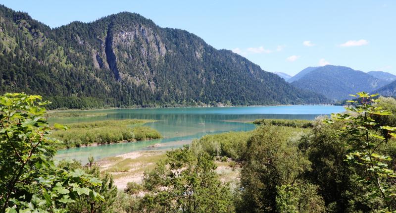
I’ve decided that, since I am limited to two photographs, one should illustrate “countryside” and the other “town”.
For the “countryside” photo, I was torn between so many sights I’d seen in the course of the week. I’ve chosen one of the lake Sylvensteinsee, photographed on the hill out of Vorderiss; on the right, you may be able to make out the bridge on the outskirts of Fall.
For the “town” photo, views from Bad Tölz were strong contenders. I’ve settled on one taken from the top of Marktstraße; the street curves round to the left and you can just see the back of the statue of Kaspar Winzerer III and the beautiful façades of the buildings lining the street.

-
-
Comment of your RAD+REISEN-Eurocycle-Team